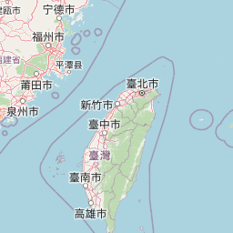
map+− OSM 臺灣通用電子地圖 臺灣通用電子地圖(灰階) 正射影像 正射影像(航照混合) Taiwan e-MapLeaflet | © OSM 物種赤腰燕 Cecropis striolata[原始紀錄物種] Cecropis striolata日期2011-3-26地點台南市北區22.99905,120.21006原始座標誤差: 100公尺海拔:35公尺觀測方式人為觀測記錄者李文珍鑑定者資料集The Taiwan Breeding Bird Survey Data授權紀錄授權:CC BY-NC來源連結https://www.gbif.org/occurrence/1658675337識別號d9e2225c-6c4b-4ba8-9cda-4171e7f935f4 (OccurrenceUUID)gbif.4693648.1658675337 (externalID)