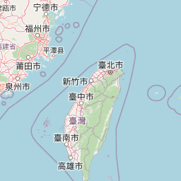
map+− OSM 臺灣通用電子地圖 臺灣通用電子地圖(灰階) 正射影像 正射影像(航照混合) Taiwan e-MapLeaflet | © OSM 物種紅頭山雀 Aegithalos concinnus[原始紀錄物種] Aegithalos concinnus日期2021-1-9地點南投縣信義鄉23.4913,120.8917海拔:2600公尺觀測方式人為觀測記錄者Sunny Tseng鑑定者資料集Xeno-canto - Bird sounds from around the world授權紀錄授權:CC BY-NC來源連結https://www.gbif.org/occurrence/3051582443識別號16a17b90-bcdc-4060-bf49-907a54affdcb (OccurrenceUUID)gbif.4693713.3051582443 (externalID)